
Hiking Martis Valley and the Tahoe Rim Trail at Brockway
If you are traveling on Highway 267 from Truckee to Northstar California, you will drive through picturesque Martis Valley. This beautiful expanse of protected meadows and forests offers trails for hikers at all levels.
The easiest hiking can be found in the valley where you will see a few places to park along the Highway or at the turnoff for glider rides.
Elevation ranges from 5,800 to 8,600 feet and hikers will find a diversity of trails in the Martis Creek Basin, Martis Valley and Brockway Summit. Some are flat trails and others have a sustainable climb that leads to breathtaking views.
The Martis Creek Reservoir was built in 1972 to reduce the flood risk to Reno. The area also includes Donner Creek and Prosser Creek, making this a great area to see local flora and fauna. It is not uncommon to hike through the meadows and discover arrow heads. Prior to the development of Martis Camp, the meadow was notorious for the architectural discoveries of the Washoe Indians.
Martis Valley Loop Trail
This 4 mile trail of packed earth is a relatively easy hike leading to wonderful mountain terrain. Runners and those hiking with their furry friends especially enjoy this trail. Dogs will find plenty of places to drink along the way.
While some vertical hikes can be challenging for non locals because of the altitude, the Martis Valley Loop Trail doesn’t present the same challenge. If you have a difficult time getting the entire family out for a hike, this is a perfect hike that allows for conversation and a first peak at the changing fall colors.
Many picnic tables allow you to pack a lunch and enjoy the sounds of nature while you eat. The only drawback to this hike is that there is not a lot of trees. Hiking in the intense mountain sun for hours will require hats, water, sunscreen and even planning this hike for the early or later part of the day. In fact, the sunrise and sunset colors add a special ambiance to this hike.
Hike to Martis Peak
As you travel on Highway 267 beyond the Northstar turnoff, you will see Martis Peak Road to the left, with a pull off for parking. During winter, Martis Peak Road has a gate, but you can still find nearby parking and hike up the road. As you travel up this dirt road, stay left at the forks, following the blue markers to the fire lookout, where you can enjoy the wonderful views of Martis Valley.
During winter, you can snowshoe or cross country ski in this area. There are many offshoots once you travel up into the mountain, so either take a map with you or mark your trail well for your descent.
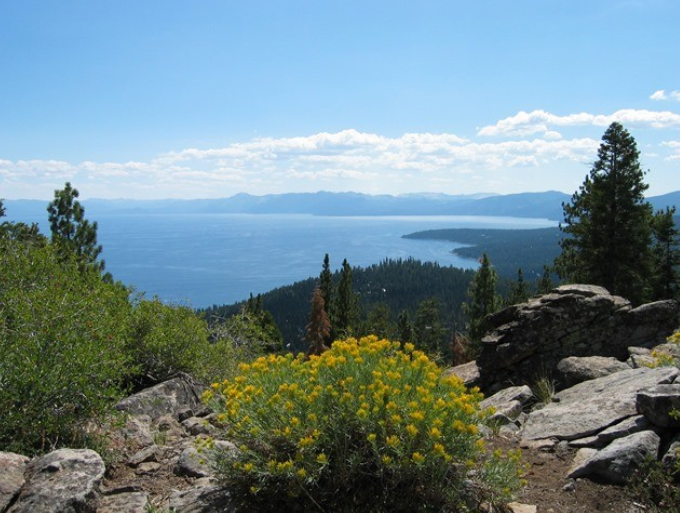
Tahoe Rim Trail to Picnic Rock
Less than a mile south of Martis Peak Road, is Brockway Summit. This dirt trail takes you from the Brockway Summit trailhead, ascending through thick forest with occasional views of Lake Tahoe. At 1.2 miles where a rock outcrop is situated, turn left, following the signs for Vista.
This scenic trail leads you to Picnic Rock where you can rest in the amazing 360 degree views of Lake Tahoe. Look for the Sierra crest and Castle Peak, with the Sierra Buttes in the distance.
During the winter, you can find snowmobile vendors offering rides to Watson Lake. This portion of the Tahoe Rim Trail winds above Tahoe Vista, Agate Bay and Tahoe City.
Thick pine forests line the road and much of it is national forest. This is an excellent middle of the day hike because of the dense shade. Most of the hike is relatively easy with a fair amount of climbing. The climbing however always leads to the best views of Lake Tahoe.
Whether you are thinking of buying or selling your home at Lake Tahoe, I would love to help you. I love living in a place with so many amazing hikes and look forward to showing you around. Contact me today!
 Market Stats
 Listing Watch
 My Home Valuation